岩石・自然あれこれ
Interesting rocks and minerals, with some nice scenes in the field.
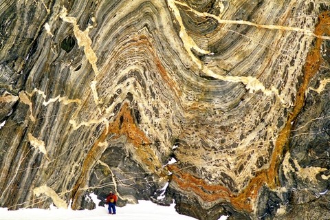
南極(大陸の衝突)
南極大陸はかつて,いくつかの大陸が衝突・合体してできた超大陸「ゴンドワナ」の一部でした。この写真は東南極・セール・ロンダーネ山地での過酷な地質調査中に発見された,激しく褶曲した片岩(変成岩の一種)の露頭で,約5億年前の大陸どうしの衝突を生々しく物語る雄弁な光景です。第32次日本南極地域観測隊夏隊の当プログラム教員が撮影。(画面左下の雪原上に人物スケール)
A magnificent outcrop of complexly folded schist, intruded by numerous veins, tells the process of continental collision that formed the Gondwana Supercontinent some 500 million years ago. This was found by the 32nd Japanese Antarctic Research Expedition at a glacially polished cliff of the Sør Rondane Mountains, East Antarctica.
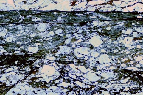
地震の痕跡・シュードタキライト
地震を起こすような断層のずれが高温高圧の地下深部で起こった場合,高速の振動による摩擦のために岩石中に微細な溶融部ができ,そこだけが特殊な岩石に変わることがあると考えられています。このような岩石を「シュードタキライト」と呼び,「地震の化石」といえるものです。写真は日高変成帯で発見された岩石の薄片(薄く切って磨いたもの)を顕微鏡で観察した像で,画面上方に横に延びる黒色の帯状の部分が,細粒な再結晶鉱物でできているシュードタキライトです。写真の横幅は約0.7 mm。(北海道様似郡様似町幌満川)
Pseudotachylite is thought to be a product of fast vibration within a shear zone during seismic activity at the deeper part of the Earth’s crust. This photomicrograph of an example from the Hidaka Metamorphic Belt in Horoman, Hokkaido, exhibits planer development of pseudotachylite (dark layer). Picture ca. 0.7 mm wide.
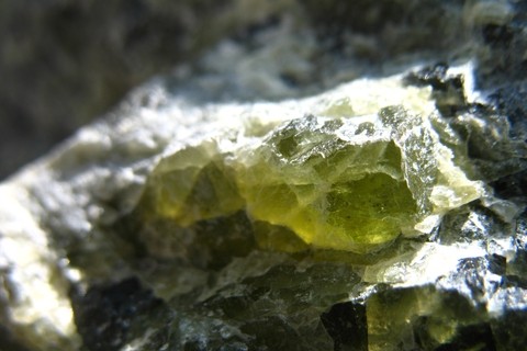
緑の鉱物・かんらん石
「かんらん」とは,オリーブの木の和名です。オリーブの実のような鮮やかな緑色をした鉱物「かんらん石」(英名olivine,オリビン)の,この透き通った色は神秘的に見えます。とくにきれいなかんらん石の結晶は「ペリドット」と呼ばれ,宝石として取り引きされます(8月の誕生石です)。写真の横幅は約3 mm。
A close-up view of a crystal of olivine, a common phenocryst-forming mineral in basic igneous rocks. Some kind of olivine is called Peridot as a gemstone. Picture ca. 3 mm wide.
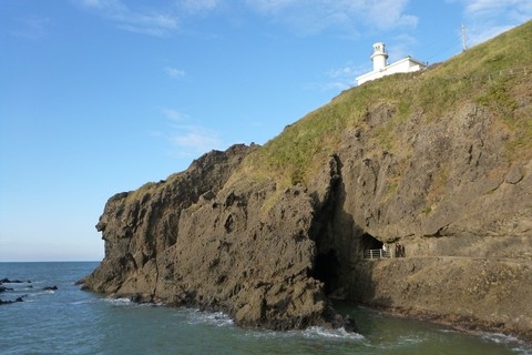
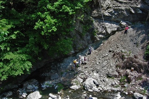
角田岬の中新世火山岩
角田岬(新潟市西蒲区)は日本海に臨む雄大な景勝地で,美しい角田岬灯台や隣接する穏やかな砂浜の角田浜海水浴場とともに,風光明媚な観光地として新潟近郊の市民に親しまれています。夏の海岸からは青い海の向こうに佐渡島もくっきりと見えます。灯台周辺のガケでは,新第三紀中新世の盛んな海底火山活動でできた,荒々しく変化に富んだ火山岩がよく観察できます。
Kakuta-misaki Cape, some 20 km southwest of Niigata city center, is a famous picnic area for its attractive setting with beautiful coast, lighthouse and thick forest behind. The cliff right under the lighthouse provides an easy access to a nice section of a Miocene subaqueous volcano.
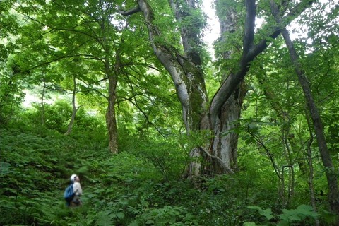
森の大木
地質調査では,ときに人跡も稀な森の中に分け入っていきます。そこでは,研究対象の岩石に出あうだけでなく,自然のままの木々が,あるいは行く手をはばみ,あるいは威厳を持って,私たちのような訪問者を迎えてくれます。写真のような大木に思いがけず出合うと,やっぱり自然てすごいなぁ,と感じます。これも,地質学をやっててよかったぁと思う瞬間です。(新潟県北部での調査にて)
When a geologist goes into the woods, he/she will meet not only exposures of interesting rocks but also many other natural wonderful things. Those include old, large trees like this, who should have been there for tens or hundreds of years, gazing countless changes of seasons around itself. Another pleasure to be a geologist.
ナップ構造(跡倉断層)
ナップとは地層や岩体が,側方に強く圧縮されて,低角~水平な断層沿いに長距離移動したものです。この露頭では,写真中央を左下から右上に通っている低角度の断層を境にして,三波川帯の御荷鉾緑色岩類の上に,後期白亜紀の跡倉層が乗り上げて(衝上して)います。(群馬県甘楽郡下仁田町)
An outcrop of the base of the Atokura Nappe in the Kanto Mountains. The Upper Cretaceous Atokura Formation (upper) overrides the Mikabu green schist of the Sambagawa Belt (lower). Shimonita Town, Gunma.
 geo.sc.niigata-u.ac.jp